Guildhall, Vermont
Guildhall, Vermont | |
|---|---|
Town | |
 | |
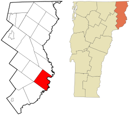
 Location in Essex County and the state of Vermont. | |
 Location of Vermont in the United States | |
| Coordinates: 44°32′47″N 71°36′38″W / 44.54639°N 71.61056°W | |
| Country | United States |
| State | Vermont |
| County | Essex |
| Area | |
• Total | 33.1 sq mi (85.7 km2) |
| • Land | 32.8 sq mi (84.9 km2) |
| • Water | 0.3 sq mi (0.8 km2) |
| Elevation | 1,877 ft (572 m) |
| Population (2020) | |
• Total | 262 |
| • Density | 8/sq mi (3.1/km2) |
| Time zone | UTC-5 (EST) |
| • Summer (DST) | UTC-4 (EDT) |
| ZIP code | 05905 |
| Area code | 802 |
| FIPS code | 50-30775[1] |
| GNIS feature ID | 1462111[2] |
| Website | www |
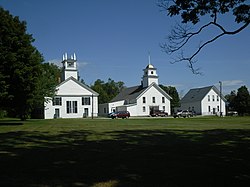
Guildhall (/ˈɡɪlhɔːl/ GIL-hawl) is a town in and the shire town[3] (county seat)[4] of Essex County, Vermont, United States. As of the 2020 census, the population was 262.[5] According to a large sign in the town center, it is the only town in the world so named. The name derives from a meeting house on the square called the Guildhall.
Guildhall is part of the Berlin, New Hampshire – Vermont Micropolitan Statistical Area.
Geography
[edit]Guildhall is in northeastern Vermont, along the Connecticut River, the border between Vermont and New Hampshire. The town is bordered to the southwest by Lunenburg, to the northwest by Granby, and to the north by Maidstone, Vermont. To the southeast, across the Connecticut, are the towns of Northumberland and Lancaster, New Hampshire.
U.S. Route 2 passes through the southern corner of the town, leading west into Lunenburg and east across the Connecticut into Lancaster. Vermont Route 102 runs north from Route 2 and follows the Connecticut into Maidstone.
According to the United States Census Bureau, the town of Guildhall has a total area of 33.1 square miles (85.7 km2), of which 32.8 square miles (84.9 km2) is land and 0.3 square miles (0.8 km2), or 0.94%, is water.[6]
The highest point is Stone Mountain, in the western part of town, with an elevation of 2,736 feet (834 m).
Demographics
[edit]| Census | Pop. | Note | %± |
|---|---|---|---|
| 1790 | 158 | — | |
| 1800 | 296 | 87.3% | |
| 1810 | 544 | 83.8% | |
| 1820 | 529 | −2.8% | |
| 1830 | 481 | −9.1% | |
| 1840 | 470 | −2.3% | |
| 1850 | 501 | 6.6% | |
| 1860 | 552 | 10.2% | |
| 1870 | 483 | −12.5% | |
| 1880 | 558 | 15.5% | |
| 1890 | 511 | −8.4% | |
| 1900 | 455 | −11.0% | |
| 1910 | 445 | −2.2% | |
| 1920 | 376 | −15.5% | |
| 1930 | 351 | −6.6% | |
| 1940 | 313 | −10.8% | |
| 1950 | 270 | −13.7% | |
| 1960 | 248 | −8.1% | |
| 1970 | 169 | −31.9% | |
| 1980 | 202 | 19.5% | |
| 1990 | 270 | 33.7% | |
| 2000 | 268 | −0.7% | |
| 2010 | 261 | −2.6% | |
| 2020 | 262 | 0.4% | |
| U.S. Decennial Census[7] | |||
As of the census[1] of 2000, there were 268 people, 106 households, and 76 families living in the town. The population density was 8.2 inhabitants per square mile (3.2/km2). There were 151 housing units at an average density of 4.6 per square mile (1.8/km2). The racial makeup of the town was 95.15% White, 0.37% Asian, 0.37% from other races, and 4.10% from two or more races. Hispanic or Latino of any race were 0.75% of the population.
There were 106 households, out of which 29.2% had children under the age of 18 living with them, 58.5% were couples living together and joined in either marriage or civil union, 4.7% had a female householder with no husband present, and 28.3% were non-families. 22.6% of all households were made up of individuals, and 15.1% had someone living alone who was 65 years of age or older. The average household size was 2.53 and the average family size was 2.96.
In the town, the population was spread out, with 24.3% under the age of 18, 6.7% from 18 to 24, 22.8% from 25 to 44, 25.0% from 45 to 64, and 21.3% who were 65 years of age or older. The median age was 43 years. For every 100 females, there were 88.7 males. For every 100 females age 18 and over, there were 86.2 males.
The median income for a household in the town was $31,750, and the median income for a family was $38,958. Males had a median income of $30,313 versus $23,438 for females. The per capita income for the town was $17,326. About 10.4% of families and 10.3% of the population were below the poverty line, including 6.3% of those under the age of eighteen and 22.0% of those 65 or over.

Climate
[edit]This climatic region is typified by large seasonal temperature differences, with warm to hot (and often humid) summers and cold (sometimes severely cold) winters. According to the Köppen Climate Classification system, Guildhall has a humid continental climate, abbreviated "Dfb" on climate maps.[8]
History
[edit]Guildhall was chartered by New Hampshire's colonial governor, Benning Wentworth, in 1761.[9] Its grantees and original settlers were from Lancaster and Lunenburg, Massachusetts, and they named towns on opposite sides of the Connecticut River in New Hampshire and Vermont for their Massachusetts hometowns.[9] The southern part of the original town of Lunenburg, Vermont was chartered as Lunenburg in 1763, while the northern portion was renamed Guildhall.[9]
After Guildhall was chartered, a small group of settlers built temporary cabins and camps and began to clear the land.[9] As the population began to grow, the first recorded town meeting took place in 1783.[9] Guildhall is heavily wooded, as are several other towns in Essex County, and lumbering was once a major portion of the local economy.[9] The Guildhall Village Historic District was listed on the National Register of Historic Places in 1980.[10] The district includes Guildhall's village center and encompasses the central common and several nearby buildings.[10]
Notable people
[edit]- Henry C. Bates, lieutenant governor of Vermont and federal judge, resided in Guildhall[11]
- Everett Chamberlin Benton, Massachusetts business executive and politician, born in Guildhall[12]
- Clem Bissonnette, member of the Vermont House of Representatives and mayor of Winooski, Vermont, resident of Guildhall[13]
- George N. Dale, Vermont lieutenant governor, lived in Guildhall before moving to Island Pond[14]
- Henry Willard Denison, diplomatic advisor to the Japanese government, born in Guildhall[15]
- Samuel Read Hall, educator and clergyman, raised in Guildhall[16]
- Janice L. Peaslee, member of the Vermont House of Representatives, resident of Guildhall[17]
- John S. Wells, U.S. Senator from New Hampshire, lived in Guildhall[18]
References
[edit]- ^ a b "U.S. Census website". United States Census Bureau. Retrieved January 31, 2008.
- ^ "US Board on Geographic Names". United States Geological Survey. October 25, 2007. Retrieved January 31, 2008.
- ^ Title 24, Part I, Chapter 1, §6, Vermont Statutes. Accessed November 1, 2007.
- ^ "Find a County". National Association of Counties. Retrieved June 7, 2011.
- ^ "Census - Geography Profile - Guildhall town, Essex County, Vermont". U.S. Census Bureau. Retrieved November 16, 2021.
- ^ "Geographic Identifiers: 2010 Census Summary File 1 (G001): Guildhall town, Essex County, Vermont". American Factfinder. U.S. Census Bureau. Archived from the original on February 13, 2020. Retrieved April 5, 2016.
- ^ "U.S. Decennial Census". United States Census Bureau. Retrieved May 16, 2015.
- ^ Climate Summary for Guildhall, Vermont
- ^ a b c d e f "Essex County: Guildhall". Kingdom Guide. Danville, VT: North Star Monthly. August 15, 2022 [September 3, 2016].
- ^ a b "National Register Information System". National Register of Historic Places. National Park Service. July 9, 2010.
- ^ Crockett, Walter Hill (1923). Vermont: The Green Mountain State. Vol. Five. New York, NY: Century History Company. p. 245 – via Google Books.
- ^ Men of Vermont. 1891. Retrieved November 19, 2009.
- ^ "Election 2020: Candidate Clem Bissonnette; Essex-Caledonia House". The Caledonian-Record. St. Johnsbury, VT. October 8, 2020 [October 7, 2020].
- ^ Necrology entry, George N. Dale, published in Proceedings of the Vermont Historical Society for 1903-04, 1905, pages 41 to 42
- ^ "Henry Willard Denison, Son of Lancaster, Counsel to the Japanese Foreign Ministry". USA: Japan-America Society of New Hampshire. Archived from the original on March 17, 2016. Retrieved March 4, 2017.
- ^ Toussaint, Tennie Gaskill (August 2, 1967). "Monument Honors Founder: First Normal School in America Established in Concord Corner". The Burlington Free Press. Burlington, VT. p. 11 – via Newspapers.com.
- ^ "Politician with a soaring passion". suncommunitynews.com. Retrieved May 6, 2023.
- ^ Bell, Charles Henry (1888). History of the Town of Exeter, New Hampshire. Boston, MA: J. E. Farwell & Co. p. 373 – via Google Books.

